Marcuse Family Homepage > Harold Marcuse page > Harold's pages index > Los Padres Mountain Biking page

posed shot (no helmet) at Wheeler Gorge, 7/11/07
Mountain Biking in the
Los Padres National Forest:

Santa Barbara to Ojai & Pine Mountain
(trip taken July 7-13, 2007)

page created by Harold Marcuse
July 15, 2007; updated 6/12/07

on the Marcuse family website;
see also Harold's UCSB Faculty homepage


Overview & Background
Books & Maps
Original San Rafael Route
Matilija-Ojai Route:
Days 1-2 Days 3-4 Days 5-6 Day 7
Newspaper
Story
Links

Overview & Background (back to top)

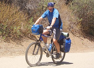
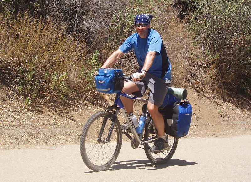
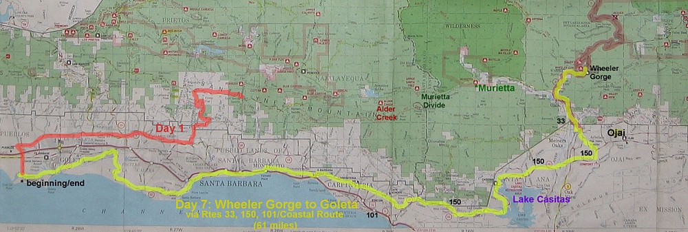
In July 2007 I took a mountain bike/camping trip through the Los Padres National Forest between Santa Barbara and Ojai, California, around the Matilija (Ma TIL ih ha) wilderness to the summit pass on Rte. 33 at Pine Mountain, and back. This was a 7-day trip, with the first 4 days completely self-contained camping at wilderness sites and a campground. A friend with a car then met me for a couple of days of more leisurely touring before I cycled home via the Coastal Bike Route.

Since someone's travelog of their trip through Denali National Park in Alaska helped me to plan and envisage a mountain bike trip there in 2005, I decided I'd share my experience in Los Padres on the web as well. (I couldn't find any descriptions on the web when planning this trip.)

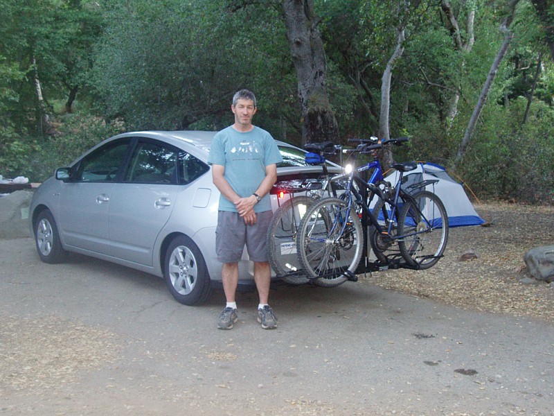
I knew I'd have 7-10 days for a bike trip this summer. At first I thought I'd drive to Utah and explore the Zion Park and Canyonlands regions with a combination of car and mountain bike, possibly with a friend or one of my kids along. I own a Toyota Prius, so the first hurdle was to figure out how best to transport a couple of bikes on the car. I've made a separate Equipping a Toyota Prius with a hitch and bike rack page to share the results of that experience. And, if I find the time, I'll make an Equipment for Mountain Bike Wilderness Camping page, about the gear & provisions I used. (Such information isn't hard to find on the web, however.)

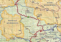
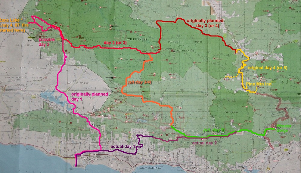
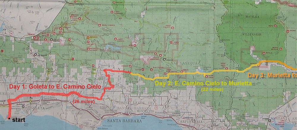
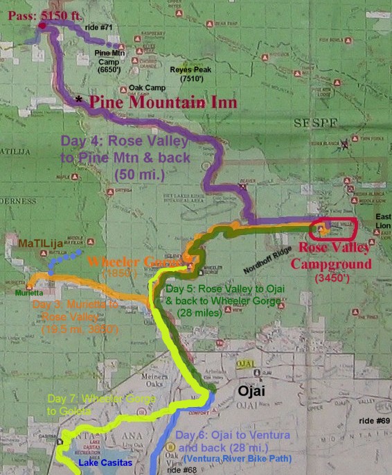
Ultimately driving to Utah seemed too ambitious for the short time, so I decided on a bike-only, start-from-home trip. At first I planned to go north around and through the San Rafael wilderness, but when a huge fire broke out at Zaca Lake on July 4, 2007, I had to change plans and go east towards 
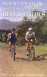
Ojai right away instead. (Zaca Fire: inciweb; 8/4/07 SB Independent report; 10/18/07 SB Independent report on the aftermath)

Books & Maps

I first purchased:

  • Don Douglass and Delaine Fragnoli (eds.), Mountain Biking: Southern California's Best 100 Trails (Bishop, CA: Fine Edge, 1993), 303 pages ($17 new/$4 used at amazon).
    Rides 79-81 describe the terrain of my originally planned trip to the Zaca Lake area, while rides 68-74 cover parts of several of the routes in the Matilija/Ojai area that I ultimately rode.
    (SB-Outdoors.org also describes some routes in this area--link in Links Section, below.)

The central headquarters of the Los Padres National Forest is just up the street from where I live (each of the various ranger districts has its own headquarters as well). I went there to purchase maps and get information. This is what I got:Covers of 4 maps of the Los Padres Nat'l Forest

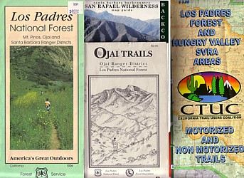
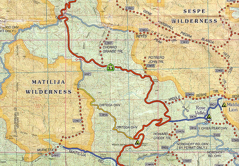
  1. The Los Padres National Forest map (first map at right, and in the route maps below). I already had the 1996 edition of this one; the new edition (ca. 2006, $9) has better color contrast and coated paper; also a few wilderness campsites have since been closed. This very detailed map does not have topographical lines (and only few very few altitudes marked), but it shows the double-track dirt roads through the backcountry better than any other map. (It is difficult to do single-track trails on a bike loaded with gear. I advise against it.)
  2. The San Rafael Wilderness map/backcountry guide, a very nice colored topographical map, the main disadvantage of which is that it only shows main trails, not all of the jeep roads marked on map 1. I wish I had had one of these for the Matilija wilderness, but I'm not sure one exists. (2005, $8)
  3. Ojai trails map
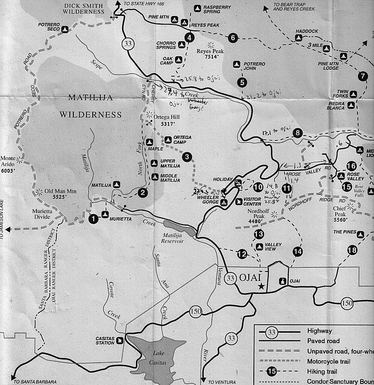
  4. An Ojai Trails guide/map ($3), which was useful for some hikes and keeping track of distances--see my notes on the enlarged version of the thumbnail at right. Note that it is NOT drawn to scale, and some of its distances are a bit off.
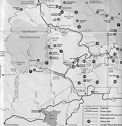
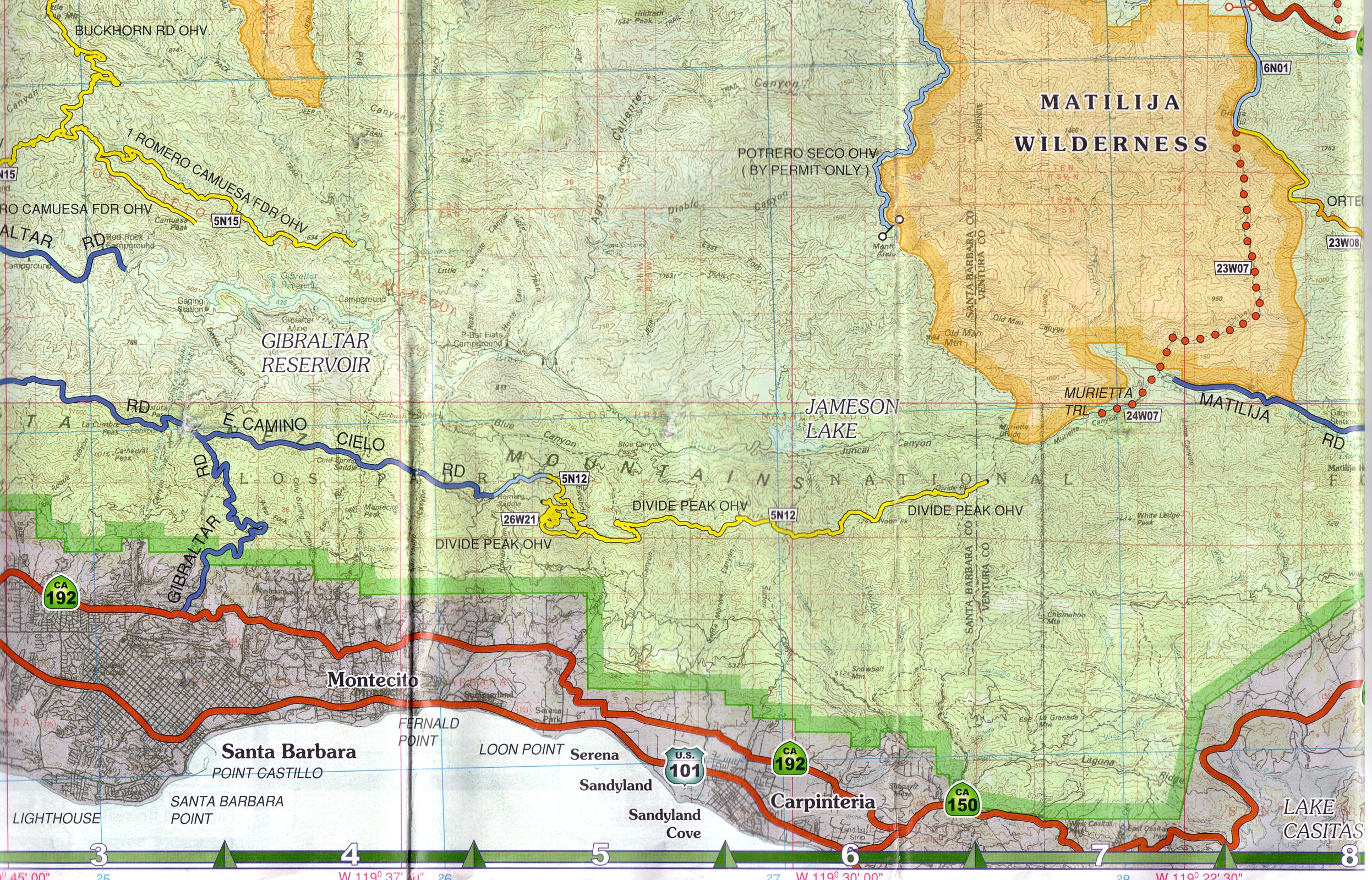
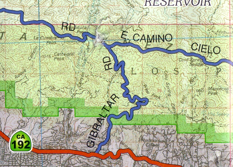
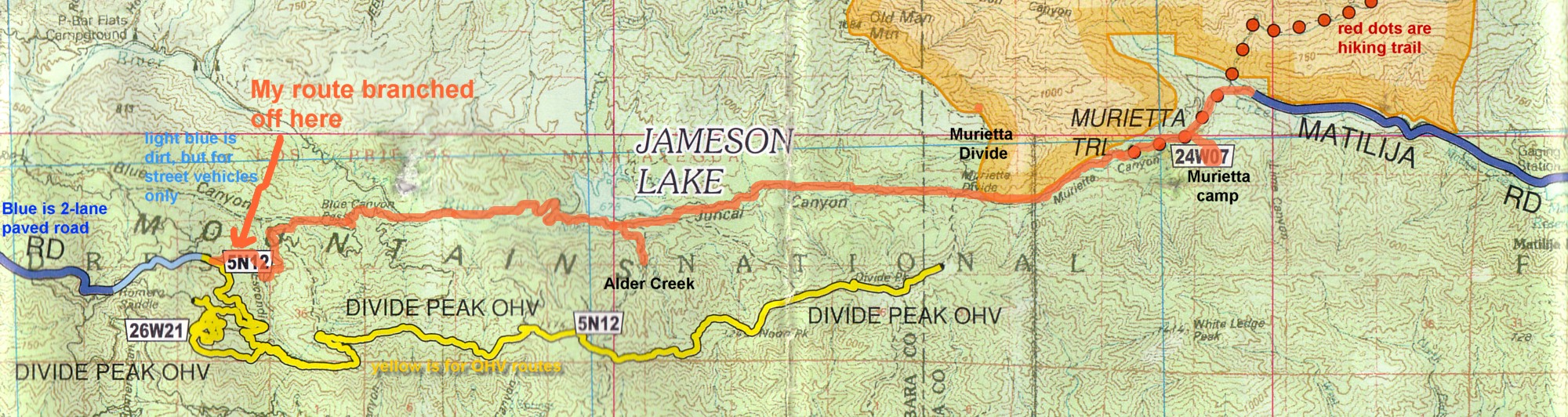
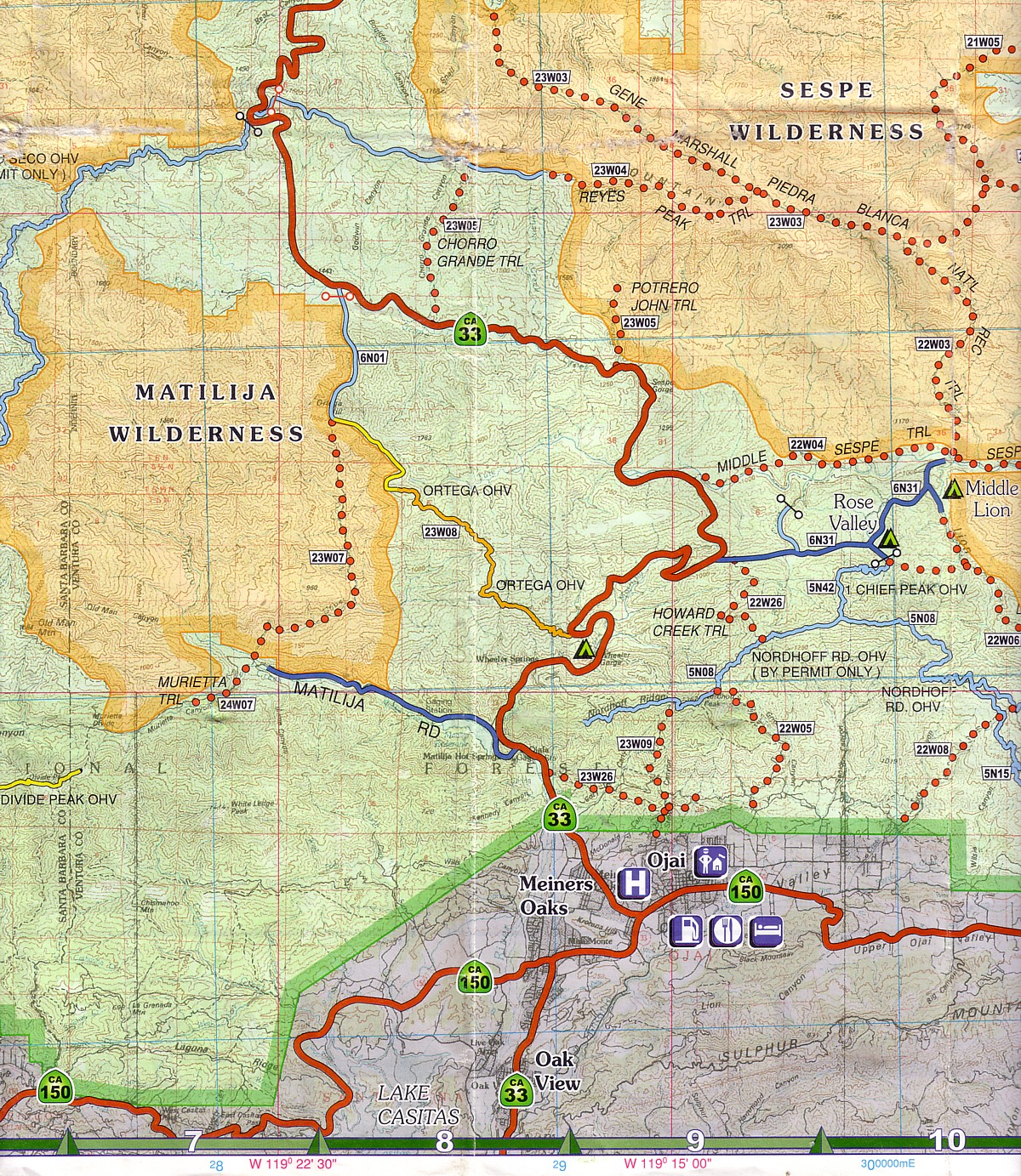
  5. They give out a free "Trail Users Coalition" topographic map that shows all of the off-highway vehicle (OHV) routes. I was concerned to avoid those roads, some of which overlapped with the jeep routes I wanted to take. It has topo lines for the areas around Matilija, but they are too small to be of much use (they're in meters, which I didn't realize until after the trip: 3333' Cathedral Peak is given as "1016"). They misled me several times into underestimating the steepness and total altitude gain on various routes. By the way, "SVRA" stands for State Vehicular Recreation Areas. scan of OHV topo map/Gibralter to Matilija

Now for the route maps. First my original plan, cancelled by the 2007 Zaca fire.


Los Padres National Forest Map showing Originally Planned Routes (2 alternatives) (click to enlarge; higher res)map with routes through Los Padres Natl Forest

Originally Planned Route: Zaca Lake & San Rafael Wilderness (back to top)

  • Day 1: Climb San Marcos pass (2600'/792m) and descend to Lake Cachuma; start climbing Cachuma saddle. Camp at Cachuma or Davy Brown (if I made good time).
  • Day 2: Go to Manzana Schoolhouse and back via Zaca Lake. This was an extremely dry year, and I was trying to find out whether I could get water from the Sisquoc river at Manzana (the Forest Service had given me the e-mail of a district ranger). However, the outbreak of the fire prevented the local ranger from responding to my inquiry. I was thinking of leaving my camping gear at Cachuma/Davy and traveling a light loop.
    Day 2 alternate: Or, if no water was available at Manzana, heading straight into the wilderness along Mission Pine Trail, to where I might find water farther upstream in the Sisquoc near Big Pine or Alamar/Bear camps.
  • Day 3: Either heading into the San Rafael wilderness (as in day 2 alternate), then heading south at Big Pine towards the Bluff camp and looping around the south edge of the wilderness. (You aren't supposed to ride any vehicle on roads inside the wilderness, although it's so isolated no one would see you. But walking your bike is nice, too.)
    Day 3 alternate 2 (dark red): going all the way through the San Rafael wilderness, then east along its north side, overlooking the dry interior Cuyama valley. End at Rancho Nuevo or Ozena camps.
  • Day 4: heading towards the Pendola ranger station and Juncal camp, past Jameson Lake to Wheeler Gorge camp (joining the route I ended up taking).
    Day 4 alternate: climbing up out of the Cuyuma valley to the 5150' pass at Pine Mountain road, meeting my friend (bringing supplies) at Pine Mountain Inn, camping nearby.

Los Padres National Forest Map showing Days 1 & 2 of Goleta-Santa Barbara-Matilija Route (click to enlarge, hi-res topo; super-hi res)
Map showing Goleta to Murietta route

Days 1-2: Goleta/Santa Barbara to Matilija Wilderness(back to top)

Three brief preliminary notes: Planet Bike 9 cycle computer

  1. my neato bike computer (Planet Bike Protege 9) yielded the distances and times given below.
    • the photo shows, from top:
      • current mph ("0.0"),
      • elapsed time since reset ("1:25:28"=1 hr, 25 mins)--pauses when not riding
      • elapsed trip distance since reset ("19.11"=19.1 miles )
      • average trip mph (13.3) and max mph (31.9) since reset.
    • two other screens change the bottom line, showing total miles traveled (odometer), current temperature and time of day.
  2. my loaded panniers weighed 28 lbs, the strapped on gear--tent, sleeping bag and mat--7 lbs. more, plus a few pounds of handlebar bag and 3 water bottles made for ca. 40+ lbs total baggage (including 4 days worth of food).
  3. I didn't have a camera along, but I provide links to other people's photos of the region.
  • Day 1: 26 miles in 4 hours on the bike, ca. 3500' elevation gain: I took the signed Crosstown Bike Route (Cathedral Oaks/Foothill Blvd) into Santa Barbara, past the mission and then up East Mountain Drive to Gibraltar Road. I didn't start until 4pm, and thus wasn't able to get as far as I had planned. It took me about 2 hours on Gibraltar Rd. to ascend ca. 3000' to East Camino Cielo, riding the first 3 miles, then pushing the last 2.8. As the sun set, smokey air started blowing in from the Zaca Fire, and lots of dirt motorbikes and rescue vehicles passed me on their way down the mountain. (Next day I saw that an SUV had overturned off the road down to Juncal--probably pulled over too far to let a descending car by.) I ended up sleeping on a ledge next to the road (web page with panoramic views), just out of sight of traffic. I left at 6:30 the next morning.
  • Day 2: 22 miles, 3:45 hours biking: I descended the paved, then dirt road towards Jameson Lake, breaking off from the OHV (all terrain vehicle) route that started beyond Divide Peak. At Juncal I had to unload my panniers to get the bike over a fence+locked gate to continue on the pleasant route to Jameson Lake, with some moderate climbing and a steep descent on a side spur to the Alder Creek camp, where I stopped to explore the aquaduct, replenish my water supplies (boiling some, and with my 3 micron filter bottle), and nap in the heat until the early afternoon. (The route up to here is described in detail in SB-Outdoors' Jameson reservoir ride; Murietta Divide ride.)
    • Around 3pm I started out for Murietta Divide, through what turned out to be some short but VERY steep canyons, in 115 degree heat. It was NOT pleasant (utterly exhausting in fact), and I ended up pushing uphill through dry, thorny grass quite a bit. I had to walk the bike a bit coming down the divide, too, since it was so steep. The trail from the jeep road in to Murietta camp turned out not to be bikeable for very long. I ended up locking my bike to a tree among the boulders of the creekbed, and carrying my gear up to the camp. There was just enough dripping water to collect and purify for cooking & drinking (and washing off poison oak).
  • Day 3, 19.5 miles , 3+ hours on the bike: continued below next map

Los Padres Map, days 3-5

Days 3-5

  • Day 3: Murietta to Rose Valley (climbing the mountain, 3850 ft)
  • Day 4: Rose Valley to Pine Mountain & back
  • Day 5: Rose Valley down to Ojai & back to Wheeler Gorge campground
  • Light Blue=Day 6: a short hike (and a bike ride, below)
  • Yellow=Day 7: back to Santa Barbara

OHV Topographic Map
OHV topographic map of route 33 area

Route 33 and Rose Valley - Days 3 & 4 (back to top)

  • Day 3: 19.5 miles , 3+ hours on the bike: coming out of Murietta thorough the private ranches and onto the paved road for a few ups and downs to route 33 (steep! at junction). Then after a rest stop at Wheeler Gorge up 33 and up and up and up to the Rose Valley turnoff. Some of the big gravel trucks constantly going up and down here passed me, but they were generally courteous. Probably over 3000' elevation gain on 33. Rose Valley Falls, Los Padres(It was fun going down on day 5, descending into the melting fog.)
    • Rose Valley camp was rather full of litter after the July 4 weekend, and hot, but it's a short hike to the waterfall, where I cooled off in a pool a bit downstream. It's an ectopic formation--instead of eating its way into the cliff, the waterfall deposits minerals to build out from the cliff face.
    • Page of Aug. 2005 photos of the Rose Falls
    • In the early evening I hiked to East Lion, but all the creeks were dried up.
  • Day 4: 50 miles, 6 hours on the bike: the day dawned and remained mercifully cloudy--an extremely rare high-humidity "monsoon" condition that even brought a few raindrops. I took along all my gear, thinking I might camp at Potrero Seco near the pass down to the Cuyama Valley or possibly at Oak Camp near Pine Mountain Inn--if water was available. Dumb me: I ended up schlepping all my camping gear to Pine Mountain and then back to Rose Valley.
    (By the way: The Spanish word potrero means "pasturing place.")

    But it was an interesting day:Pine Mountain Inn
    Turns out that Pine Mountain Inn, where I had planned to get water and meet my friend the next day, has been closed for several years. Coincidentally, owner Tom Wolf was there to meet a photographer from the local newspaper for an article about Wolf's travails trying to get the proper permits to reopen. We chatted at 9am and he gave me a few bottles of water from his cooler, and some advice about the route ahead (see ride #71 in the 100 Best Mountain Biking book). I ended up riding about 4 miles up the Pine Mountain Road from the summit pass on route 33, then parking my bike and hiking to the top, where I had lunch in the Pine Forest overlooking the lush irrigated patches far below along the Cuyama River. After coming down I explored the road to Potrero Seco on the west side of 33 (ride #74), where I had planned to spend a night, but turned back because I wanted to get back to Rose Valley to replenish my supply of water.Pine Mountain Inn passage in book
    When I got back to Pine Mtn Inn at 1pm, the Ventura County Star photographer was there. He snapped a bunch of pictures of yours truly as I came and went, and interviewed me about the Inn. (See newspaper story, below, and pictures at right--click them for color versions.) He asked me to point out the passage in the book that mentioned the Inn, immortalizing my grubby, Pine-Mountain-sap-stained finger in the process.
    The ride back to Rose Valley was pleasant under the cloud cover--I never would have attempted the Pine Mountain Road if it had been sunny. My fellow Rose Valley campers from the day before--two drifters living out of their car/pickup respectively, welcomed me back. If I had left my camping gear there I would have had a much more pleasant ride (oh well). I jotted down a message for my friend and gave it to a passing motorist, asking him to relay it via cell phone once he got into cell range in Ojai. We would meet the next day down in Wheeler Gorge instead of at the Pine Mountain Inn.
    • In the evening I hiked up the gated OHV road part of the way to Nordhoff ridge, with some spectacular views all around (see ride #69, also #70 in the 100 Best mountain biking book; marked as a light blue permit-only route on the OHV topo map).
  • Day 5, 28 miles, 2 hrs, 50 mins riding: dark green; described below map
Los Padres Map, days 3-5

Days 5-7

  • Day 5: Rose Valley down to Ojai & back to Wheeler Gorge campground
  • Day 6: Ojai to Ventura along Ventura River bike path (& back)
  • Day 7: Wheeler Gorge back to Goleta on rts. 33, 150 and Coastal bike route (101 & streets)

Hi-res Topo map;
even higher res.

Days 5 & 6 (back to top)

  • Day 5, 28 miles, 2 hrs, 50 mins riding: I zoomed down the mountain before 8am, descending into the fog at about 2000'. Ojai Trails mapI went into Ojai to the nice breakfast cafe Eggs N Things next to Vons (at the "T" intersection of 33 near 150)--Ojai prides itself on its artistic heritage and has outlawed chain restaurants. [Bodee's Restaurant, about halfway down 33 between Wheeler Gorge and Ojai, didn't open until the afternoon.] After purchasing supplies at Vons (I had used up all the food I had brought with me, except one freeze-dried meal), I ascended back to Wheeler Gorge to meet my friend. The Wheeler ranger house has 6 hummingbird feeders on its porch, with multiple birds at each one--nice compensation for the fact the water had been shut off because they had forgotten to test it for parasites (my filter bottle kept me from worrying about those, though, when I found an unlocked tap). In the campground I managed to slip and fall over on the mossy spillway that separates the two sides of the campground--very slick and invisibly potholed--be careful! We hiked the nature trail that leaves from the very top of the campground and found a nice streamside campsite (no. 28 I think).
Wheeler Gorge campsite--Prius+Bike Rack page Me at the Wheeler Gorge campsite; bike on Prius
me posing on bike at Wheeler Gorge
  • Day 6, 28 miles, 2 3/4 hours on the bike: first we drove, retracing my day 3 route back to near Murietta, and hiked up the Matilija north fork and back down. Then we went into Ojai for lunch in the picturesque downtown, and biked the Ojai-Ventura river bike route starting from the "T" (Vons parking lot). We had heard of Jud Fine's 1999 "Mark" public art sculpture project, which didn't start until Foster Park, close to Ventura. But it was a nice ride, nonetheless, along the river as well as behind abandoned oil factory and active drilling installations, ending at another Vons shopping plaza in Ventura.
  • Day 7, 61 miles, 5 1/2 hours on the bike: continued below next map

Los Padres Map, route Wheeler to Goleta

Last Day - Ojai to Goleta (back to top)

  • Day 7, 61 miles, 5 1/2 hours on the bike: as you go around Lake Casitas, this route climbs steeply several times, but of course there are the descents on the other side, finally gorgeous going down into Carpenteria. You get to ride through the agricultural areas with lots of flower nurseries, turning toward the 101 at the Polo club (lots of rich folks out this way). At Summerland the bike path has its own fenced in corridor right next to the freeway, then on residential side streets as you approach Montecito. You cross over the freeway past the bird sanctuary at the Santa Barbara Zoo and the famous Four Seasons Biltmore hotel. The Coastal Route winds through Hope Ranch (many more rich folks here) to hook up with the bike-only trail from Turnpike to Goleta Beach before UCSB. From there it's just a hop to my house (my daily commute to work).

Newspaper Story: Ventura County Star, Friday, July 13, 2007 (back to top)

on-line version at VenturaCountyStar.com, with reader comments and two videos


Links (back to top)

      • (see thumbnail)
  • T sells most of these maps and more (for instance Raymond Ford's 224 page 2001 Santa Barbara Mountain Biking, ).

page created by Harold Marcuse, July 15, 2007, last updated: see header
back to top, to the Harold Marcuse Personal page; Harold Marcuse Faculty homepage